Strong winds and extreme fire behavior caused the 6-week-old Cedar Creek Fire to make another big run east of Sweet Home on Saturday. The fire produced towering pyrocumulus smoke clouds and lightning, forced more evacuations (though some were scaled back), breached containment lines, and was brought back to zero containment.
Twenty-nine states and almost 1,000 firefighters have been enlisted to assist in putting out the rapidly spreading fire, according to KTVZ. Since late last week, a wildfire in Oregon has doubled in size, endangering thousands of houses, and engulfing the Interstate 5 corridor in thick smoke, including the Portland metropolitan area.
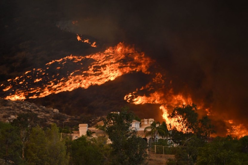
More than 2,000 Oregon Homes Are Evacuated as Cedar Creek Fire Quadruples
On August 1, amid a lightning storm, the Cedar Creek Fire started. According to officials, the fire had reached roughly 86,000 acres as of Sunday and had breached existing lines, which reduced containment to 0%. By Sunday, fire activity had subsided, and some evacuation orders had been lowered from Level 3 "Go Now" to Level 2 "Be Set."
More than 2,200 residences and hundreds of commercial structures are under threat from the fire. Most of these structures are located in the adjoining communities of Oakridge and Westfire, which have a combined population of roughly 3,500 people. On Friday, officials issued evacuation orders.
The fire, which had been only approximately 18,000 acres on Wednesday but had grown to more than four times that size by Sunday, was made worse by blustery gusts, high temperatures, and dry conditions late last week and into Saturday, according to OPB.
The Goat Rocks Fire in Washington state, which was caused by lightning and forced the closure of the US, is located south of Mount Rainier National Park. East of the community of Packwood, homes were evacuated due to Highway 12. In reaction to the Kalama fire in the Gifford Pinchot National Forest southwest of Mount St. Helens, evacuation orders were also issued for several villages in Cowlitz County.
High-voltage transmission lines owned by Bonneville Power Administration that cross the Cascade Mountains are at risk due to the amount of smoke and particulates in the air, which can affect the lines, according to Peter Mongillo, a spokesman with Snohomish Regional Fire and Rescue who was on the scene as part of the overall incident command center.
If circumstances changed and those lines did need to be pulled out of operation, there would probably be no service disruption for customers because there are still other transmission lines operating. Customers of Bonneville include the Seattle-based Puget Sound Energy and the Snohomish County Public Utility District.
Portland General Electric first cut power to around 30,000 customers across 12 service regions to reduce the likelihood of additional fires, but by Saturday, that figure had risen to more than 37,000. That number has fallen back to around 30,000 by late Saturday afternoon.
In a little village on the Pacific Coast where a wildfire broke out two years ago, as well as in several areas to the southeast of Salem, Pacific Power cut off service to more than 7,000 people. On Saturday, there were 12,000 more Pacific Power customers without service, CBS News reported.
Read Also: Moscow Promises Grains, Other Support as Free Aid To Poor Countries Affected by Western Sanctions
Nearby Areas Started To Decrease Evacuation
Near the Cedar Creek Fire, the Lane County Sheriff's office has started to lower some evacuation levels. Additionally, Oregon Highway 58 has been reopened up to milepost 36 east of Oakridge. Westfire and Oakridge, as well as the regions west of Salmon Creek, south of Laurel Butte Road, and north of the Middle Fork Willamette River, have all received level 2 evacuation notices.
The High Prairie area, which comprises High Prairie Road, Brock Road, Bar BL Ranch Road, Nubian Way, Mountain View Road, and Huckleberry Lane, is now not open for evacuation or readmission.
Also still under level 3 evacuation and closed are Westfir-Oakridge Road from Westfir city limits to Roberts Road, McFarland Road, and Oakridge north of Laurel Butte Road, east of Salmon Creek.
Green waters Park and the region around Hills Creek Reservoir to the south of Highway 58 are still under level 3 evacuation orders. From milepost 36 east of Oakridge until milepost 70 at Crescent Lake Highway, Highway 58 is still closed, as per Register Guard.
Related Article: $1,400 Stimulus Checks To Be Distributed by Biden Administration; Here's When and How!
@Youtube
© 2026 HNGN, All rights reserved. Do not reproduce without permission.


