The Tonga tsunami was captured by satellite imaging that was captured in real-time as the undersea volcano vented its fury more than 20 miles up in the atmosphere. The locals called Hunga-Tonga-Hunga-Ha'apai, which is non-existent as the island has been wiped off the map.
A tsunami wave propagated from the center of the volcanic eruption, reaching Fiji, Australia, New Zealand, and US coastal areas; such is the blast's power.
Hunga-Tonga-Hunga-Ha'apai largest eruption since
When the eruption cleared up after twelve hours after the sky darkened from pyroclastic material, the images seen from space show the Hunga-Tonga-Hunga-Ha'apai gone after the catastrophic explosion, reported the Sun UK.
Tongatapu, the main island, was damaged heavily by the giant wave. The pictures show destroyed areas in the north to the south side of the areas struck.
In 2014, when the volcano erupted, that caused damage to Uoleva and Nomuka, islands close by.
Although the Hunga-Tonga volcano has spewed constantly in the past few decades, preliminary evidence indicates this is the largest eruption after Mount Pinatubo in the Philippines 30 years ago, remarked New Zealand-based volcanologist Shane Cronin, cited Reuters.
This blast has been seen via a satellite, Cronin concluded. Based on the U.N. Office for the Coordination of Humanitarian Affairs (OCHA) update on the eruption, they warned that another blast might be in the works to caution the locals.
Two low-lying islands, the Fonoi and Mango, have been mounting due to distress beacons from the disaster struck by the Tonga tsunami.
Assessing the Tonga tsunami damage
The Tonga figures suggest that 36 people live on Mango and 69 on Fonoi. It comes after her husband James recovered the remains of his wife Angela Glover, a 50-year-old British charity worker who was swept away by the tsunami. Fatalities were registered as two people drowned in the Peru coastal areas hit by the high waves.
This volcano had an influence as far as Fiji, New Zealand, the United States, and even Japan. Aid workers said that about 80,000 Tongans were adversely affected by the event.
Meanwhile, reconnaissance flights have been deployed by Australia and New Zealand to assess the damage from the eruption for appropriate responses.
Zed Seselja, Australia's Pacific Minister, claimed Australian police have visited coastlines and discovered significant damage, involving "houses blown around from the sheer force of the volcanic and seismic event, noted Business World Online.
Curtis Tu'ihalangingie, Tonga's deputy head of mission in Australia, is very concerned and alarmed about the possibility of COVID-19 propagating to the island, which is COVID-free.
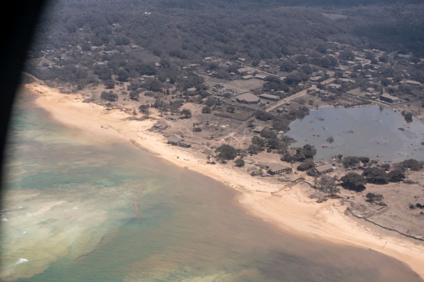
The Haatafu Beach Resort is located on the Hihifo Peninsula, about 13 miles west of the Nukualofa capital. It was destroyed, remarked the proprietors.
According to a report, its family management fled for their lives through woods to evade the tsunami. Its western shoreline, as well as Kanukupolu town, has indeed been entirely demolished.
Officials from the Red Cross were mobilizing their infrastructure to attend to what they characterized as the deadliest volcanic eruption in the Pacific in generations.
The generation of the Tonga tsunami has caused severe after-effects and devastation from the volcanic event, and no one knows how much has been damaged exactly yet.
Related Article: Hunga Tonga Volcano Undergoes Catastrophic Explosion Generating Aerial Shockwave Reaching New Zealand, Sparking Tsunami Alerts
© 2026 HNGN, All rights reserved. Do not reproduce without permission.