
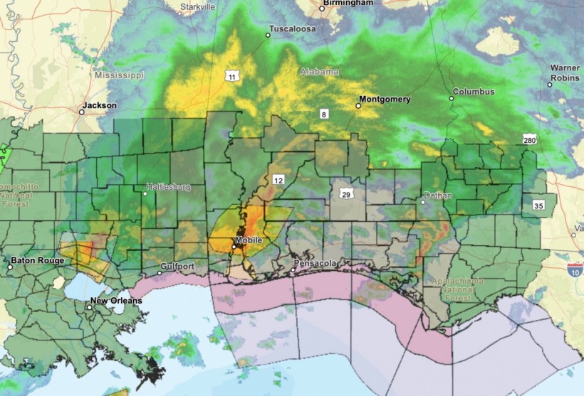
(Photo : National Weather Service)
A National Weather Service map shows an area of the Gulf Coast that could see severe weather on Monday.
Severe thunderstorms and flash flooding could impact portions of the Gulf Coast on Monday and the Southeast Tuesday. More than 50 million people are at risk of severe weather to start the week.
A strengthening surface low-pressure system will sweep across the southern tier as a warm front moves north across the Gulf Coast ahead of the system.
That will prime conditions for severe thunderstorms on Monday from central and east Texas across portions of the Gulf Coast states of Alabama, Mississippi, and Georgia to the Florida Panhandle, according to the National Weather Service.
Potential storm hazards will include significant wind gusts, very large hail and a few tornadoes. Heavy rainfall will also lead to a chance of flash flooding.
There is a moderate risk of flooding in effect from Louisiana to the western Florida Panhandle. Heavy rainfall will also be possible further north in parts of the Mid-Mississippi Valley and Upper Midwest along a slow-moving low pressure system.
The system will continue to move east through mid-week, and the warm front will lift north across the Southeast while the trailing cold front moves across the Lower Mississippi Valley on Tuesday.
Widespread showers and thunderstorms are forecast to develop across the eastern U.S. on Tuesday, and although the severe thunderstorm threat will be lower than it was on Monday, isolated severe storms with heavy rainfall will be possible in the Southeast.
By Tuesday night, showers and storms will expand into the northeast as well, then the southern low pressure system will push into the Atlantic on Wednesday.
Temperatures will also be above average for parts of southern Texas and central and south Florida where temperatures will be in the 90s and lower 100s, and some daily high-temperature records may be tied or broken.