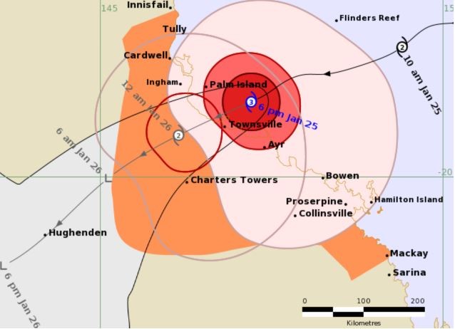
The Australian state of Queensland prepares to hunker down as a category 3 cyclone named "Kirrily" is expected to make landfall in the state's northern city of Townsville overnight.

As of around 18:30 local time (08:30 UTC), the cyclone is 60 kilometers northeast of the regional center and is moving at 26 kph while bringing 170 kph winds and heavy rainfall.
According to the Australian Bureau of Meteorology (BOM), "Kirrily" could bring intense rainfall, especially near the eye of the storm.
Residents and businesses have been advised by state authorities to prepare to either weather the storm or relocate whenever applicable.
Read Also: Official Reports Over 70 Fatalities in Mali as Unregulated Gold Mine Cave-In Occurs
Winds, Rainfall Picking Up
Photos coming out of northern Queensland showed the cyclone's initial impact and response, such as fallen trees by the roadside, people putting sandbags on their doorways, and securing all doors and windows.
Meteorologists further said that the cyclone could also sever power lines, cutting electricity and causing further property damage.
Aside from Townsville, places from south of Innisfail to Mackay would also be heavily affected by the cyclone, which would come on the eve of Australia Day. Further inland, places like Charters Towers were advised to prepare as the cyclone could hit the town next, albeit in a weaker manner than on the coastline.
Ports and airfields in the area where "Kirrily" is expected to pass through were also closed as a precaution.
Related Article: Phillip Island Mass Drowning: 4th Person Dies in Hospital After 3 Others Drowned at Scene


